Showing posts with label Pine forest. Show all posts

Sunday 12 November 2017

KHALABAT SATTIAN - MURREE HILLS

Khalabat is a hilly village of Murree hills in Rawalpindi district, Pakistan. Khalabat is 23 miles south-east of Murree town - a popular hill station, 31 miles north-east of Islamabad, the capital of Pakistan. It is in the lower Himalayan hills and this area has cold, snowy winters, relatively cool summer with drastically escalated rain. During monsoon village top mostly remains covered by fog, monsoon starts in July and continues til September.
Maize is the traditional crop of the area, land holdings are small due to the hilly terrain and production is hardly sufficient for subsistence. Apple, apricot, pear, plum, walnut, cherry, raspberry, fig and pine nuts are main fruit of Khalabat.
The village has forest land as well as cultivated land. Part of the forest is kept by the government ; some of it, called guzara, is for community use. The forest is covered by thick blue pine trees. The top peak of the village is at altitude of 7,417 ft which is known as "Kullah", and the distance between this peak and Patriata top is just 300 meters, Patriata top is the highest point of the Murree hills which consequently the highest point of the Punjab as well.
There is a dense blue pines forest between Khalabat and Patriata, which is home to different wild animals like leopard, bear, monkey, fox and various species of pheasant and rabbit.
Forest is full of wilderness and it has large number of culinary and medicinal herbs.
The third type of land is used for house construction. Due to the need for terraces, houses and fields are small and homes are scattered.
There are four Mosques in village including Central Jammah Mosque. There is one primary school for boys and one for girls, one private high school for boys and girls and a college for girls. The literacy rate of Khalabat is 91.5%.
The village consists of five parts. The villagers are of different ethnic groups and each occupies a specific area of the village.
The largest ethnic group in the village consists of Satti who are also the second largest tribe in the Murree Hills. There are four tribes inhabiting the Murree hills: Abbasi, Satti, Dhanial and Kethwal. Khalabat is a Satti village situated in Satti area. In this village the first migrants were three Satti brothers from a neighboring village to the south east of Khalabat. Dhanials came later, the few households of Kethwals are the latest arrivals in the village.
Ethnic group Percentage in Khalabat
Satti 66%
Dhanial 24%
Kethwal 9%
others 1%


                                                                By : Anjum Satti


Friday 3 November 2017

PANJPEER ROCKS

Just a handful of people in Islamabad know about this exciting hiking opportunity very near to them. Panjpeer is the highest point of the Danoi Ridge in Kotli Sattian/Kahuta. It is called Panjpeer because of a shrine it has at the top. Locals believe this was a place where five saints came and got settled. It is at an altitude of approximately 1800 meters. In winters the top gets a few ft of snow each year.
Danoi hike  starts from the Lehtrar rest house on the Lehtrar Road. This road links Islamabad to Bagh via Kotli Sattian. Total distance between Islamabad and Lehtrar town is around 40 Kilometers. Rest house is behind the petrol pump just a little ahead of the main bazaar. The hike starts behind this rest house and is actually an abandoned jeep road. In a couple of hours, this path reaches Danoi rest house while passing through a beautiful pine forest. Danoi rest house Is at an approximate altitude of 1300 meters.


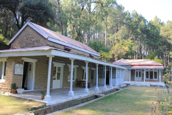
Danoi rest house


If you have lesser time, another option is to skip the first part and start the hike right from Danoi rest house itself where a metalled road joins from Lehtrar. To reach rest house on a vehicle, follow the Lehtrar road for a further few kilometers towards Kotli Sattian till a place called as Thun Mor from where a road turns right towards Baba Saeen Matka Sharif shrine in Kamra. There is also a sign board indicating this shrine. Total traveling distance from Islamabad to Danoi rest house is around 60 kilometers. If you are coming on your own vehicle, you can park it here. Tell the rest house guards to take care of it, and they will do it well. The rest house was built in 1928 and is right in the middle of the beautiful pine forest. You can also spend the night here through an advanced booking from the forest department office near Sawan station, Rawalpindi but they are generally reluctant to entertain people without reference.
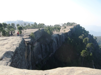
Just a few steps from the rest house, there will be many paths climbing upwards. You can take any of these which will cross the road at a few points before joining it back. Road can also be skipped if one continues to climb up a little towards right to reach the ridge.  One can also spot some arrows for the directions which are marked by ASG but they are getting diminished with time. Continuing with the shortcuts and the road, the road turns in to a rough jeep track. Soon, you will be able to see Murree and Patriata on your left towards west. Enjoying the pine forest and the beautiful views hike trek offers, you will reach a place where there are big boulders stretched over a large area. This part is the specialty of this trek. Nowhere else in the whole region, you will find any thing like this. It is not just these large stretched boulders, throughout the trek you will notice large rocks of very unique size and structure. These rocks are also very tempting from rock climbing point of view however I am not sure if anyone has ever attempted them. At some places they offer a scary vertical drop of rock with a height of more 100-200 ft. Continuing on the trail will take you to Panjpeer  which can be spotted from the distance by a large junk of jumbled up trees on the top. If one keeps walking along the edge and skip the road turning right, towards the shrine, one can reach the end of ridge with a nice view point from where river Jehlum can also be seen. Total travel time from Danoi to this place or the shrine is 2-3 hours. On clear days, from the top, you can see Makra and other mountains of Kaghan area on your north while different peaks of Kashmir are visible on the east.


Panjpeer Rocks


From Panjpeer, you can walk down back to Danoi if you have your vehicle parked there. Otherwise, another option is to drop down on the other side towards East to the Jehlum river through Narh. This path ends at Azad Pattan where a bridge links Azad Kashmir to this part of Punjab over river Jehlum. Public transport can be taken from Azad Pattan that will reach Islamabd in around 90 minutes via Kahuta and Sihala. Though it seems much less from the top, the trek on the way down takes around 3-4 hours.

Salman Rashid explored Danoi rest house and has mentioned it in one of his articles here.  Also, check this post for another account of the same hike done by backpacker.

                                      Click here for more details

PAKISTAN'S PEOPLE LED DISASTER MANAGEMENT (PPLDM)

Pakistan's People Led Disaster Management Movement , (PPLDM) is based on the belief that disaster management should be in the hands of...